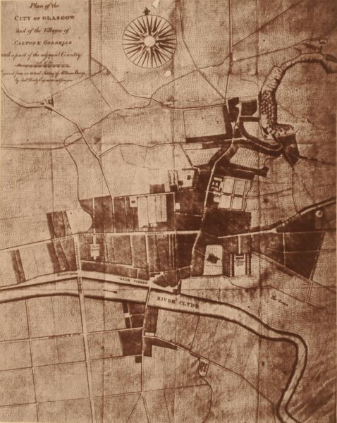
This photograph is a fac simile, on a reduced scale, of a plan appended to Gibson's "History of Glasgow," published in 1777. (1) That plan was from an actual Survey by James Barrie, shortly before. The plan is now rare, for, by some fatality, few of the existing copies of Gibson's excellent work possess it. A reproduction of it seems, therefore, not inappropriate in a volume such as the present.
When the Survey thus alluded to was made by Barrie, about 100 years ago, Glasgow was a comparatively small town. The population did not exceed 40,000, now about 600,000. The streets were only 18, now over 1,000, in number, off which branched many "wynds," or closes. Of these streets, however, only eight included what was the real old Glasgow, or nucleus from which has expanded, by a succession of "new towns," the present great city.
These more ancient streets were, the High Street, Drygait, Rottenrow, Gallowgait, Saltmarket, Bridgegait, Stockwell, and Trongait. To these were added, in 1724, Candleriggs and King Street; while an old wynd, called Gibson's, which branched off Saltmarket, westward as far as the south end of the "Laigh Kirk Close," was about the same time improved, and carried west to King Street, thus connecting the latter directly with Saltmarket. This amplified wynd received the name of Prince's Street. When M'Ure wrote, in 1736 (about 40 years previous to Gibson), the eleven streets above enumerated comprehended the whole then existing. He very quaintly compares these, and the wynds, to a "wooden comb," whereof the main streets constituted the wood in the middle, and the numerous wynds, or closes, the teeth on each side.
But, about the middle of last century, these ancient features began to undergo a change, by the opening of a number of new streets, a process which has continued almost constantly ever since. This expansion began by the demolition of the old "Ports," or Gates, which had defined the limits of the ancient City, and by the opening a new series of streets outside. The earliest and most important took place beyond, or to the west of, the Barrier and Gate which stood across the west end of Trongate, at the head of Stockwell, popularly known as the "West-Port." What is now Argyle Street was then a mere country road, with corn fields, "kail-yeards," and a few straggling thatched houses on each side. It was commonly called "the Westergait," or "the Dumbarton road," and, being uncausewayed, was full of ruts and sloughs.
But, when the West Port was taken down, this suburban road was, by degrees, causewayed a little further west, till it reached what is now Jamaica Street, which was opened when the bridge was erected there, about 1772. Westward from that point, what is now Western Argyle Street was known as "Anderston Walk," with hedges and pailings on each side, and only an occasional house.
This improvement on the comparatively modern Argyle Street, induced proprietors on each side to open new streets, at right angles to it, through their respective grounds and lay these off in building lots. In this way they formed Virginia, Miller, Queen (an old lone, improved by the owners of ground on both sides, under a written agreement in 1776), Buchanan, Jamaica, Maxwell, and Dunlop Streets, with one Square, St. Enoch's, the first of the kind in Glasgow. The particulars of these new streets will be found in the third volume of "Glasgow Past and Present."
Now, this was the state of matters when Barrie made his survey, circa 1776, and the limits of the city are delineated in conformity. A glance at the map shows both the old and the new streets, and the wynds, the westmost street being Buchanan Street, and the eastmost being "Dowhill," off Gallowgait. There are no streets off the north side of Trongate between Candleriggs and Virginia Street. In other words, the line of houses in Trongate was unbroken, and all behind them open fields or gardens. Ingram Street had not been formed but is marked as "Cow Lane," and "Shuttle Street," the latter of which communicated with High Street, by the Grammar School Wynd. Originally there were two "Cow Lones," which joined each other. One of these was what is now Queen Street, and the other was the "Back Cow Lone," now Ingram Street. In Barrie's day the latter of these lones was a mere drove road, uncausewayed, for driving out the cows of the citizens in the High Street district to be pastured about Cowcaddens, under charge of the town-herd, who blew a horn as he came slowly down from his abode in Rottenrow, in the morning, to warn the burghers to turn out their bestial, and in the evening returned with the animals by the same route, and with the same musical performance. (2) Moreover, the Lone was a favourite place for milking cows; and servants and children were sent there with jugs, as in a country district, for warm milk. (3) Boys, also, bent on a different mission, resorted to the Lone for "mauks," or bait, for fishing, the place being famous on that account. This continued till the Lone was causewayed, improved, and named Ingram Street, circa 1781. Prior to that alteration the Back Cow Lone was bounded on the south by a low stone wall, which extended from the head of the Candleriggs westward to Miller Street, and closed in the north ends of the various gardens and stripes of open ground which lay between it and the backs of the houses on the north side of Trongate. The Lone was flanked on the north side by an old hedge, with many "slaps," from the Candleriggs westward to Queen Street. Such was the original condition of this now important artery when map was prepared.
But while Barrie's map shows the lines of the new streets in his day, these were then only partially built up. Many of the plots in them were vacant. In Buchanan Street, particularly, two houses alone had been erected, viz., the edifice still standing at the south-east corner (the first built in the whole street), and another on the east side, near the mouth of what is now the Arcade. St. Enoch's burn, now tunnelled over in modern West Nile and Mitchell Streets, was, in Barrie's time, an open trouting stream, with rows of trees on its banks.
With regard to James Barrie himself, he came to Glasgow in 1734, at the age of seventeen, (4) and ultimately was eminent as a land surveyor. He executed a variety of surveys of the district, and larger maps of the city and neighbourhood. Most of the new streets already mentioned were laid off by him, as appears from old papers. He resided in "Crossbaskets Land," Gallowgate, near Spoutmouth. His name appears in the first Glasgow Directory, published by John Tait, stationer, High Street, in 1783, and in those by Nathaniel Jones of later dates.
(1) John Gibson, who wrote the history of Glasgow, was originally a merchant there, but ruined like many others by the American war. He afterwards became an accountant in Saltmarket, and is so described in Tail's Directory of 1783. He added to his business that of an auctioneer, in partnership with Richard Smellie, another unfortunate merchant. The firm was "J. Gibson and R. Smellie." Their auction-rooms were in Trongait, nearly opposite the Laigh Kirk close and steeple. They had a fair business. Many of their advertisements appear in "The Glasgow Mercury of 1786-7." Mr. Gibson wrote the history soon after his misfortunes. The volume is well written, and shows him to have been possessed of much general as well as local information, and a well educated man, accustomed to literary composition. His book affords a striking contrast to the confused uneuphonious jumble by M'Ure, forty years before. Gibson died 17th August, 1787 [Glasgow Mercury, 22nd of that month and year). In the same newspaper there is a notice, by Mr. Smellie, of the dissolution of the firm in consequence of the death. Mr. Smellie carried on the business, and, at the end of the intimation of dissolution, he announced that he would sell, by auction, "the whole stock of china which belongs to the concern, consisting of breakfast cups and saucers (sic), mugs and sets, pint and half-pint basons, punchbowls, jars and beakers, Indian soy in pint bottles, and a few pints of Indian sweet-meats."
(2) The name of the last town-herd who thus did duty was John Picken. His "horn" is still extant. It is that of a cow, with a notch around the mouth for a string to attach it to the person of this droll functionary, and is sadly begrimmed with "reek." It can "tout" yet.
(3) See on this subject a queerish book, titled "Kick for a Bite," by the late Mrs. Agnes Baird, of the Bridgegate, a copy of which is in the library of the Glasgow Philosophical Society.
(4) This is ascertained from his own deposition as a witness in a celebrated action of damages, at the instance of William Fleming, against the Magistrates of Glasgow, in 1767. Barrie had been employed by the civic authorities to make a survey of the Molendinar Burn, in connection with that lawsuit. A curious circumstance was stated by an old man, a witness in that case, that in his remembrance the water of the Molendinar Burn was "so pure and sweet," that the people in Bridgegate (where he resided) were accustomed to use it in brewing ale.
Back to Contents